Follow Our Trip

Welcome to the Travel Blog! We'll try to update everyone on our trip, things we've seen and done, and include cool photos when possible. Feel free to leave us messages, and we're always looking for tips on places to go next!

Wednesday, February 29, 2012

North Island West Coast, and more rain dodging

We crossed the strait again and immediately set off for Whanganui, since we had liked the town earlier but not spent much time there. Our rabid weather forecast checking convinced us that the rain would hold off until we had a chance to visit Taranaki. We got a site along the river and had a nice time watching the baby pukekos wander about. We then went into town and enjoyed the nice old buildings and the cute main street (though everything closes promptly at 5). Treated ourselves to dinner at an Indian place, which was super awesome after quite a while of cooking for ourselves and a long driving/ferry day.

The next day we stopped again at Rapido for a coffee. Guess what, it was raining. The forecast suddenly moved the storm up a whole day and we drove along the coast toward Taranaki while it poured steadily on us. Upon reaching the turnoff to the mountain which we couldn't see, we decided it wasn't worth walking around in the rain for and continued on to the northern end of the mountain peninsula. We stopped at White Cliffs brewery, as it was raining, and mused that the rain might stop if we just had a beer. The beer was pretty good, though not spectacular, and we watched it rain from our vantage near the bar. But behold, our plan actually worked and by the time we left there was a break in the rain and the hint of not-clouds to the north. Amazing!!

We drove a short way down the road to the White Cliffs and walked along the black sand beach below the cliffs. Not sure how the beach is black when the cliffs are white, but hey we're not geologists. We continued north along the highway and passed through the Awakino Gorge. It was beautiful. This section of the west coast of the North Island is at least as beautiful as the scenic route along the west coast of the South Island. We passed the Waitomo area again and continued on to Cambridge, where we spent the night at the holiday park, while it rained. And rained. And rained.

The next day we went to the nearby Maungatautari Ecological Park, another mainland island behind lots of fencing. The place is obviously not very well traveled, as there is a tiny carpark followed by a little more than 1 km of walking through some cow fields. The little orange markers led us astray and we had to bushwhack our way to the gate. Once there, we found that the trail was closed due to construction, though they invited us to walk along the super steep gravel maintenance road instead. We did, for awhile. After a steep climb we decided to just hang out and listen to the birds next to the Jurassic Park style fence. Perhaps not the best stop, but at least it didn't rain on us.

We drove north from there, stopping briefly in Matamata for the Hobbiton sign.

Then we headed to the Coromandel, finding only a bit of rain on the way. We had a nice time here before, and we'd like to spend more time in the area. Too bad it's supposed to rain a lot. Hopefully we'll find a bit of sun here and there...

Saturday, February 25, 2012

Marlborough Wine Country, Nelson Lakes, and Marlborough Sounds

We have reached the end of our South Island journey. Crazy! Only three more weeks left before we have to return to reality.

Blenheim was a good choice of location. While it wasn't super sunny, it was only a bit cloudy and definitely not raining. We took ourselves just out of town to visit the wineries of Marlborough, New Zealand's largest (by volume) wine producing region by a long shot. If you've had NZ wine, it's probably been from Marlborough. And it was probably a Sauv Blanc. This area is famous worldwide for it, and deservedly so. We visited four of the wineries in the area.

We stopped first at Highfield based on a Lonely Planet recommendation. Apparently it's not an uncommon recommendation and they get a lot of "if you go to only one place, go there" people. Their claim to fame is a viewing tower with a nice vista over the valley and the surrounding hills. The wine was fine. Nothing wrong, but nothing to really write home about. We left with just some pictures and a recommendation for our next stop.

Mahi. Wow. This was a good one. The wine is mostly single-vineyard, which we love, and all natural fermentation, which we really love. The style of wine was perfect for us, and everything was very good. We had a very nice tasting and left with a Sauv Blanc, Chardonnay, and a Pinot Noir. And, of course, a recommendation for the next place and some good ideas for lunch.

We ignored those good ideas and instead went to a takeaway in Renwick for a hot dog and a "Renwick burger" complete with a beef patty, chopped steak, onions, tomato, lettuce, a fried egg, bacon, a huge slab of melted cheese, mushrooms, and a pineapple slice. So. Good. Beard-washing was necessary after that enjoyment.

Then we went down the street [we must impress how close all these wineries are to each other] to Te Whare Ra, one of the local organic wineries. The wine here was pretty good. Not as nice as Mahi, but still good. We came away with a bottle of Sauv Blanc. They were out of both of their reds, which was a shame because it would have been interesting to see what they did with them.

After that we hit Seresin. This was another big hit with a solid lineup and some goofy unique winemaking ideas. We tore ourselves away with only a Chardonnay, though you can buy their excellent Sauv Blanc at wine.com. Big thumbs up for Marlborough.

The next day we were pretty wined out. Since the weather in Nelson Lakes had cleared up [i.e. it stopped snowing], we took a drive down the valley to visit Rotoiti, which Hilary had been to last time. When we got there, there was some sort of waka [canoe] race going on and it was really crowded. It was also kind of cold. Nevertheless, we took a walk along the lake and spotted some tui and bellbirds. Strangely, about half way down our trail, Hilary remembered hiking along the very same 10 years ago... apparently, when she was here before she went for a run on the same trail.

From Rotoiti we drove to Picton. We had a chill night with our Chardonnay from Seresin and The Mummy from the video library at the holiday park. The next day we returned to the Queen Charlotte Track to do a walk. The day started a little grey but the sun came out and we had a very nice ~18 km walk along the track including a random cow-on-track sighting. On the way back, the cow was gone. Not really sure where it went...

Tomorrow morning we make the short drive back to the ferry and then the North Island.

Thursday, February 23, 2012

Arthur's Pass and the West Coast part 2

After driving up the east coast from Dunedin in the rain, we stopped at Ashburton for the night at Coronation Park. It was a weird little place with a cramped lawn for camping and mostly semi-permanent residents. Not exactly welcoming... The next morning we decided to skip Christchurch since the reports were that the downtown was still totally cordoned off and full of rubble. Instead we took the road to Methven and got some coffee at a little cafe while it rained. Then we took the road through the very pretty Rakaia Gorge and then hooked up with the Great Alpine Highway SH-73 that runs through Arthur's Pass to the west coast. We drove up to Flock Hill Station, near Craigieburn Park, but they were closed for the day since someone left a tap running and their water tanks had been emptied. Bummer! Instead we turned around and went back to Springfield to stay at Smylies, a very cute and homey place with a giant library of books and dvds (half in Japanese, but still there were a lot) to hang out while, you guessed it, it rained.

The next day we got a short break from the wet weather and we stopped in the Castle Hill area to walk around the crazy limestone formations.


After that we got ourselves a spot at Flock Hill (now open), then drove to Craigieburn for a walk to Helicopter Hill. We swear the last bit of track is longer than the 500 m advertised. The view was rather nice and we took the long way back to the car on the way down.


The next day we took a walk along the Bealey Spur track. The weather was not quite as nice as the day before, with some rain blowing through. Bealey Spur is supposedly the place to go though, since it's on the east side of the pass and the rain was coming in from the west. After a bit of walking in the rain, it started to really rain and when our pants were thoroughly wet we decided to turn back before it got truly awful. Good thing too, when we got to the car the rain was even worse. We returned to Flock Hill and found a truckload of teenagers on some school trip. After enduring the melodrama for a few hours while it rained, we escaped to the bar at the main lodge for adult beverages.

The next day the rain was supposed to hold off on our side of the pass until about 1 or 2pm. We took our chances and went to the Bealey Valley track on the north side of Arthur's Pass village (but still southeast of the actual pass). We got some decent not-rain for weather, but the creeks were up and we had to turn around when the crossings started getting a bit deep and wide, in case we got caught in the rain. Good thing too, when we returned to Flock Hill around 2pm it started pouring.

And it rained. And rained. And rained. Thankfully the building was watertight and fairly warm (with the heater on) and nearly deserted. We hung out, cooked a nice dinner, and chilled while it rained. Eventually we had to go back to the car, but the grass was so wet we decided to leave it in the gravel parking lot overnight. It stopped raining around 6am. Seriously, the rain was ridiculous and never-ending.  We thought we'd get a five minute break here or there to rearrange the car for sleeping, but it never stopped.

The next morning, we got going in a rare bit of half-sun, but not more than about 15 km later we ran into (literally) some rockfall. The rocks took a tire, so we pulled over to attach our spare. The very first car that passed us also stopped to help (super friendly NZ!), before we even had the car jacked up all the way, and we found out that our tire iron only worked on 4 of the 5 nuts. I guess the story is that the 5th nut is different to prevent tire theft. Lot of good that did us. We flagged down another car who had one of those 4-pronged tire irons and got the last nut off and the donut on. Thanks random strangers!

Our choices for destination were Greymouth or Christchurch, since nowhere else nearby would have a reliable source of tires. Either was about 120 km away. We picked Greymouth since that was the direction we were going anyway. Wow, what a fun road! Perhaps we have mentioned that it had been raining a bit recently. This day, not 10 minutes after resuming driving, the rain came in again accompanied by "gale force" winds of about 100 km/h in the high passes. Lucky for us, we were crossing the highest pass across the Southern Alps, followed by the crazy steep Otira Gorge with 16% grades and exposed bridges. Waterfalls were sheeting off the cliffs, rain was blowing up (up!!) the road in huge waves, and at one point we came to a bridge which was now a ford. We weren't going to cross it at all, but the oncoming traffic did just fine and we saw it was only a few inches of water. [this was one of the many, many one-lane bridges in NZ.] It was a bit scary though, even for just a few inches it was moving really quickly and the car had to struggle a bit to get through.

Eventually (we were driving really, really slowly) we made it across the pass and through the gorge, and when we reached the foothills the weather slacked to a mix of rain, wind, and sun--sometimes all three at once. But still it was a vast improvement over the mountain weather. We got to Greymouth and found the tyre shop that a construction guy along the road had recommended to us. They happened to have a gently-used tire in our size for sale and plenty of time to install it, so we were in and out in about 20 minutes for only $60. Nice!

After a gas stop and a trip to the market, we continued up the west coast along SH-6. Lonely Planet says this is one of the best road trips in the world, and it's pretty darn good. The wind was up and had been blowing for days, so the waves were impressively crashing into the rocky coast. The rivers were all swollen to massive proportions and were gushing down from the hills, accompanied by waterfalls galore. We stopped in Punakaiki for a walk among the Pancake Rocks and Blowholes; these blowholes actually blew. And we stopped a lot along the road to enjoy the scenery. Even gray and misty the coast is beautiful. A quick check of the weather in Punakaiki led us to the conclusion it was time to flee to sunshine, so we blew past Nelson Lakes (forecast: rain, rain, and snow!) and drove into Marlborough to stay at the Top 10 in Blenheim (forecast: some clouds, some sun).  Hellloooooo, wine country!

Friday, February 17, 2012

Fiordland, the Catlins, and Otago Peninsula

On our way south from the Wanaka region, we stopped in Old Town Cromwell for a break. We found a cute little historical village, no cars allowed, on the edge of the lake. [This is apparently a section of the old town that was moved and preserved before the town flooded after the construction of a dam.] We also found Armando's Kitchen, a very pleasant coffee shop/cafe/produce mart. We lingered over some flat whites (beans ground to order) and conversation with Armando. Afterward we took a wander around Old Town and the mix of art shops and museum pieces. A little further down the road we took a pit stop in Arrowtown. This has a much more built-up "historical" district but is still pleasant to walk around.

We blew past Queenstown since we can't afford to skydive, jetboat, or otherwise pay to fling ourselves through space. Instead we stopped for lunch at a picnic site along Lake Wakatipu between Queenstown and Kingston.

A short drive later we found ourselves in Te Anau, the base for Fiordland. We got a space at Fiordland Great Views Holiday Park, though there were only views of a hedge (and the sheep on the other side of the bush) and all the extra "amenities" they advertise cost more, from the spa (where an extra cost makes sense) to the forks and laundry pegs (huh?). We had a chill day there, walking to town to get groceries for the trip into Fiordland and booking a kayak trip on Milford Sound. We left Te Anau and drove to Gunn Camp along the Hollyford, about 40 km from Milford. We quickly found out that the Hollyford Valley is famous for its sandflies.

After figuring out accomodations, we took the trail to Lake Marian, situated in a hanging valley amongst the mountains. The trail was steep for much of the way and very rocky, necessitating some clambering. Fun!!! Along the way we passed Marion Falls and stopped for a snack. We arrived at Lake Marian to bits of sunshine and a beautiful lake, with views of glaciers and snow.


The next day we woke up super early to arrive in Milford at 7am for our kayak trip. The road was dark and deserted, and we got to drive through the Homer Tunnel without seeing another car. After a short trip from the meeting point to the launch, we donned our neoprene skirts and fancy yellow mist jackets and set out into the fiord. [fjord? what happened to the j?] The day was gorgeous, with no rain, light wind, and only spotty clouds. Apparently Milford was having a bit of a heat wave, and it got to about 20 C. The water was calm and clear and we had a great time paddling about 18 km from the bay at the base of the fiord to the Tasman Sea. A few sea birds were about and we came across lots of NZ fur seals. A boat met us where the sea surge starting to knock us around (gently, whee!) and took us back to Milford.


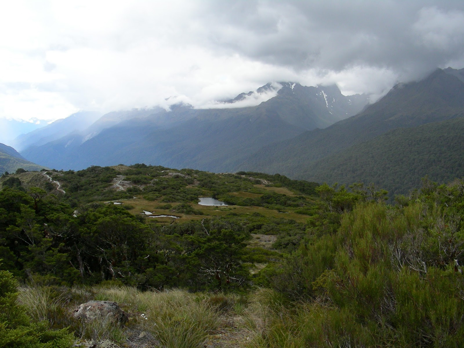
After a short rest and lunch, we took the Routeburn Track a short distance to the trail to Key Summit. Many, many switchbacks later we arrived at the top (918 m), where a strange and beautiful alpine forest/marsh sat. We also got views of Lake Marian, where we had been the day before. The nature trail at the summit was the best one we've done yet.


It was windy that night, which kept the sandflies mostly at bay. Even more wind in the morning meant we barely got eaten at all as we packed up to leave the fiords. We stopped again at Te Anau for gas and a snack at the friendly Sandfly Cafe. After that we continued along the Southern Scenic Route and picked up a couple sausages in Tuatapere (the sausage capital of NZ, apparently) and stopped for a nice ocean/mountain view at McCracken's Rest along the coast.

A short drive later we were in Invercargill, where we found the Invercargill Brewery and had a very lovely (and free!) tasting. Their beer was great (and they contract brew stuff from all over NZ) and we picked up a 1.25 L rigger of their NZ pils, a bottle of Boysenberry, and a vintage 2008 bottle of their Smokin' Bishop. We picked up a site in the park across the river for the night and enjoyed the pils with dinner after a walk/run through the totara forest in the park.

The next day we took another park walk through forest and along the estuary. Then we headed for the Catlins. We took the coastal route and stopped at Slope Point (the southernmost point on the island), Porpoise Bay, and Curio Bay. We got to see the super-rare Hector's dolphins that live in Porpoise bay jumping around--the resident pod numbers only about 20--and the most-rare yellow-eyed penguins at Curio Bay among the petrified trees the litter the beach. Pretty cool!


After that we drove along and wound up at a cute little holiday park near Surat Bay. We took an evening stroll along the river mouth toward the ocean, but never got there as we were blocked by the (also rare) NZ sea lions that were a little agitated after the previous group of tourists got a little too close. The sunset still looked nice from the river.

The next day we drove to nearby Jack's Bay and took a walk to Jack's Blowhole. As we keep finding in NZ, things are not really what they are named after (see the lagoon incident in Bay of Islands). The "blowhole" was more of a sink that was connected to ocean, and it didn't really blow despite our being there at high tide. It was an impressively large hole, though, and the surrounding scenery was great. We then stopped off at Nugget Point to see the lighthouse and watch the sea birds fly around.


Then we headed north for the Otago Peninsula just outside Dunedin. We got a spot in the town of Portobello (not sure about the relation to the mushroom) and drove out to Pilot Beach near sunset. There we and a ton of other tourists all stared at the one blue penguin on the beach for quite some time. And we waited, and waited, and then after about half the folks had begged off due to darkness a little group (flock?) of penguins came swimming in from the ocean. They popped out, waddled through the gulls, and headed for their burrows in the sand. Blue penguins are the smallest in the world and they looked really cute walking around the beach with their bright white bellies and grey/blue backs. After they got to the burrows, they started making little cooing noises, fully cementing the "cutest penguin in the world" title.

The next morning we headed for the Dunedin farmer's market. We're now 3 for 3 for visiting farmers' markets in the rain. It was a really nice market and we picked up food for a couple days, including some nice looking local beef and some truly beautiful kale. Time to head north and back into the mountains.

Friday, February 10, 2012

Southern Lakes and More Glaciers

We spent several days in the Wanaka/Hawea area, continuously deciding in the morning to stay one more day, and one more day. This area is gorgeous. We kept our camp at Lake Hawea, which is much more chill than Lake Wanaka about 15 km down the road. Wanaka is a crazy tourist town full of tour operators, overpriced restaurants, and jewelry stores. Hawea has just a couple restaurants, one of which is also the town general store and coffee shop, and is just a friendly place. We stopped at the hotel/restaurant/bar/bottle shop after finding only expensive beer at the general store/cafeteria/restaurant and were able to buy just 4 bottles of beer after a complimentary sample from the tap to see if we liked it. So nice! [side note: as in South America, here "cafeteria" means "place that makes coffee".]

Aside from the nice town and the awesome site we got for our car along the lake, this area is chock full of walking trails ranging from leisurely strolls along the lake or river to multi-day hikes in the mountains. We took a lovely walk from our car through town and the surrounding farms & sheep to the base of the mountains east of the lake. There is a trail there leading to some views, but since we had walked about 7 km just to get to the trailhead, we only walked about 1 km further (through the cows) before turning around. On our way back, we took the trail along the lake shore. Beautiful and windy!


We also drove through Wanaka and up the lovely Matukituki Valley. After 30 km of gravel roads full of sheep and cows, we got to the Rob Roy Valley trail that runs along Rob Roy creek and to a view of the Rob Roy Glacier (Hil note: the glacier pics are for you, Mom, since we got rained out in glacier-land when we were here together). Now this is a spectacular glacier, with not just a river rushing away from it but a thousand sparkling cascades plunging down the sheer mountainside. Wow! If you're visiting NZ, do this walk.


(Hil note: the road sign is for you, Dad... the only difference being that we did not run ourselves into a hole and did not break our car... )

We were also gifted with a clear night and the awesomely bright full moon rising over Lake Hawea. To the south we could see the Pointers and the Southern Cross (it looks more like a kite...), despite the brightness of the moon that blocked out a huge portion of the stars. Stupendous.

Though we could happily spend another year here doing all the different walks, we've decided to head south and get to the "walking capital" of Te Anau, which is also the base for exploring Fiordland.